


Low depression in Bay of Bengal can turn into cyclonic storm


.png )
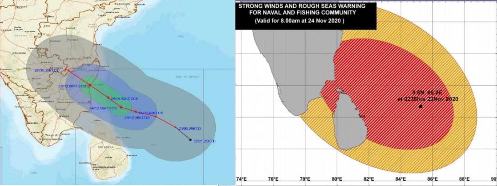
Colombo (News 1st); The Sri Lankan Met Department has warned the low-pressure area over Bay of Bengal has become a depression and is expected to intensify further into a cyclonic storm during next 24 hours
It is likely to move northwestwards over the Eastern-Northern Sea areas towards the Northeast coast of Srilanka on 24th of November.
Under the influence of the aforementioned system, the possibility for intermittent showers or thundershowers and sudden roughness, associated with a sudden increase of wind speed up to (70-80)kmph is high over Eastern and Northern, deep and shallow sea areas during the next 24 hours.
Wind speed can increase up to (50-60) kmph at times over sea area extending from Puttalam to Matara via Colombo.
There is a possibility that nearshore sea areas off the coast extending from Mannar to Pottuvil via Kankesanthurai, Trincomalee, and Batticaloa may experience surges due to the effect of swell waves, having (2.0-3.0) m height during next few days.
For Land Area Very strong gusty winds (60-70)kmph can be expected in Eastern, Northern and Northcentral. Strong gusty winds (40-50)kmph elsewhere.
Province |
23rd Nov. |
24th Nov. |
25th Nov. |
26th Nov. |
Northern |
Rainfalls at many places with (100- 150)mm at several places. Above 150mm rainfalls at isolated places |
Rainfalls at most of places with (100- 150)mm at several places. Above 150mm rainfalls at isolated places |
Rainfall at many places with (100- 150)mm at some places. About 150mm rainfalls at isolated places |
Several spells of showers |
North-Central |
Rainfall about (25- 50)mm at several places. 100mm at isolated places |
Rainfall about (12.5- 25)mm at several places |
Several spells of showers |
Ligh showers |
Eastern |
Rainfalls at many places with (50- 100)mm at several places. Above 100mm rainfalls at isolated places |
Rainfall about (12.5- 25)mm at several places |
Several spells of showers |
Afternoon thundershowers |
Other Articles


Featured News
-835300_550x300.jpg)


News 1st, MTV Channel (Pvt) Ltd, MBC Networks (Pvt) Ltd, 45/3, Braybrooke Street, Colombo-02.
T.P : +94 114 792 700,
Fax : +94 114 792 733
T.P : +94 114 792 700,
Fax : +94 114 792 733


 |  |  |
|---|---|---|
 |  |  |
 |  |  |
 |

.gif)